HIKE
.jpg)
HIKING OPTIONS
There are several options for hikes leaving from Bear Valley. Hikes range in distance and duration. Please refer to the information below to determine which option is best suited for you. Maps will be available for participants.
Short hikes (under one hour)
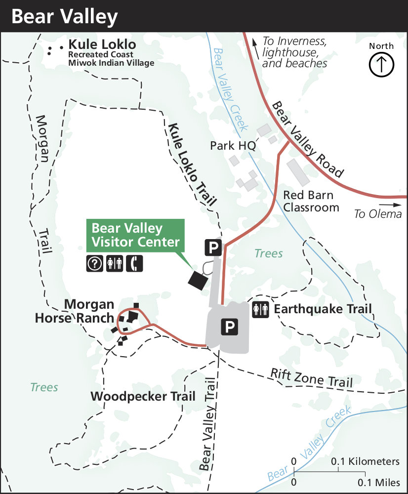
Earthquake Trail
Distance: 1 km / 0.6 mi.
A short paved loop explores the San Andreas Fault Zone. Interpretive signs provide information about the San Andreas Fault, the 1906 earthquake, and the geology of the area. This trail begins at the southeast corner of the Bear Valley Picnic Area, just across the access road from the Bear Valley Visitor Center.
Woodpecker Trail
Distance: 1.1 km / 0.7 mi.
This loop trail explores the beautiful local forest and meadow ecosystems of Bear Valley. An interpretive brochure describing some plants and animals you may see can be obtained at the trailhead or at the Bear Valley Visitor Center. This trail begins at the Bear Valley Trailhead, at the south end of the Bear Valley Parking Lot.
Kule Loklo Trail
Distance: 1.3 km / 0.8 mi.
A short path leads up to a replica of a Coast Miwok Indian village. Interpretive signs briefly describe Coast Miwok culture and history and the structures in the village. From Kule Loklo, return on the same trail, or continue around the horse pasture to return via the Morgan Horse Ranch. This trail begins at the north end of the Bear Valley Parking Lot, about 100 meters (110 yards) from the the Bear Valley Visitor Center.
Divide Meadow via Bear Valley Trail
Distance: 5.1 km / 3.2 mi.
A casual stroll through mixed Douglas fir forest and along Bear Valley Creek to an open grassy meadow. Several benches along the way offer great resting spots in the shade. Divide Meadow is a nice place to picnic in the sun. The hike begins at the Bear Valley Trailhead, located at the south end of the Bear Valley Parking Lot.
Mt. Wittenberg Loop
Distance: approx. 8 km / 5 mi.
This hike features a steep 400 meter (1300 feet) climb to the highest point in the park (426 m / 1407 ft), with a few limited views of the seashore and Olema Valley near the ridge crest. The loop passes through a dense mixed Douglas fir and oak forest and several open meadows. Start at the Bear Valley Trailhead and follow the Bear Valley Trail south for 0.3 km (0.2 mi.). Turn right on to the Mt. Wittenberg Trail and climb all the way to the Z Ranch-Mt. Wittenberg trail junction along the ridge crest. From this junction, a 0.6 km (0.4 mi.) trail leads to the summit of Mt. Wittenberg. The once unobstructed views from near the summit have, since 2000, become obstructed by dense Douglas fir thickets that sprouted shortly after the 1995 Vision Fire. From the Z Ranch-Mt. Wittenberg trail junction, one may turn north along the Z Ranch Trail and then follow the Horse Trail back to the trailhead. Or, if one continues along Mt. Wittenberg Trail to the junction with the Meadow and Sky trails, one may be rewarded (weather dependent) with views looking west across the peninsula to the Pacific Ocean. From the Meadow-Sky trail junction, descend the Meadow Trail to the Bear Valley Trail. Turn left to return to the Bear Valley Trailhead.
Even Longer hikes (three to six hours)
Bear Valley Trail
Distance: 13.1 km / 8.2 mi.
Sky-Bear Valley Loop
Distance: 17 km / 10.5 mi.
A nice varied hike, through mixed Douglas fir forest, meadows, and coastal scrub with coastal views and beach access. Begin at the Bear Valley Trailhead, at the south end of the Bear Valley Parking Lot. Follow the Bear Valley Trail for 0.3 km (0.2 mi). Turn right on to the Mt. Wittenberg Trail and climb (400 m / 1300 ft. elevation change in 2.9 km / 1.8 mi.) all the way to the Z Ranch-Mt. Wittenberg trail junction along the ridge crest. From this junction, a 0.6 km (0.4 mi.) trail leads to the summit of Mt. Wittenberg. The once unobstructed views from near the summit have, since 2000, become obstructed by dense Douglas fir thickets that sprouted shortly after the 1995 Vision Fire. From the the Z Ranch-Mt. Wittenberg trail junction, continue along the Mt. Wittenberg trail to the junction with the Sky Trail. Follow the Sky Trail south through the forest all the way to the Coast Trail. A thirty-minute detour to the north on the Coast Trail will bring you to Kelham Beach. Otherwise, head south on the Coast Trail to the Bear Valley Trail. Enjoy your last coastal view here, before returning via the Bear Valley Trail along Coast Creek through beautiful buckeyes and mixed Douglas forest.
Woodward Valley Loop
Distance: approx. 21 km / 13 mi.
This trail includes beautiful forest and spectacular coastal hiking. Begin at the Bear Valley Trailhead, climbing either the Mt. Wittenberg or the Meadow Trail to the Sky Trail. Continue south along the Sky Trail to the Woodward Valley, one of the lushest, greenest trails in the park. Follow the Woodward Valley all the way down to the Coast Trail before heading south to the Bear Valley Trail. Open ocean views are plentiful along the last 0.8 km (0.5 mi.) of the Woodward Valley Trail and along the length of the Coast Trail. Beach access is marked along your way at both Sculptured Beach and Kelham Beach. Both are beautiful and remote beaches. From the Coast-Bear Valley Trail junction, follow Bear Valley Trail east and north along a gentle grade through beautiful buckeyes, oaks, and Douglas firs back to the Bear Valley Visitor Center.
ADDITIONAL INFORMATION ON HIKING IN POINT REYES NATIONAL SEASHORE:
https://www.nps.gov/pore/planyourvisit/hiking_guide.htm